


We save you time, and money.
Residential & Commercial Drone Roof Surveys Across the UK
ProVision Drones provides professional drone roof surveys and inspections for residential, commercial and historic properties across Essex, London and nationwide.
Using high-resolution drone imagery, we provide detailed views of roofs, chimneys and difficult-to-access areas without the need for costly scaffolding or specialist access equipment. Where required, inspections can be combined with detailed roof condition reports prepared by experienced independent RICS surveyors.

About Us
We are fully accredited and fully insured, drone roof surveyors. With over 20 years in the building industry working on large commercial projects and residential developments, we have covered it all.
20
Years of Experience
Fully insured up to £10 Million


450+
Roofs Surveyed
CAA Licensed
Experienced drone pilots
Independent RICS surveyors


Professional Drone Survey Services
Commercial Drone Roof Surveys
We provide professional commercial drone roof surveys for property managers, block management companies, schools, churches, local authorities, commercial property owners and other organisations across the UK.
High-resolution drone imagery allows us to inspect large, complex and difficult-to-access roofs safely and efficiently, reducing the need for scaffolding or specialist access equipment during the initial inspection.
Where required, our imagery can be assessed by our experienced independent RICS surveyor and incorporated into a detailed roof condition report, including photographic evidence, observations and recommendations.
Client Testimonial
"Pro-Vision Drones provide a professional and comprehensive service.
Their survey reports are clear, easy to understand, with strong photographic evidence to support their findings.
The buildings surveyed are complex, and large with multiple roof elements, chimneys and rooflines to consider.
Altogether a high level of service which has enabled us effective programmes for maintenance works."

Commercial Drone Roof Surveys →


Residential Drone Roof Surveys
Our residential drone roof surveys provide detailed high-resolution imagery of roofs, chimneys and other areas that can be difficult or unsafe to inspect from ground level.
We can inspect pitched and flat roofs, chimneys, ridge lines, leadwork, roof coverings, gutters, fascias and other external elements, providing clear photographic evidence of their visible condition.
Whether you're investigating a suspected defect, planning repairs, buying a property or simply want to understand the condition of your roof, professional analysis and an independent RICS surveyor's report can also be provided where required.
Residential Drone Roof Surveys →
Flat Roof Drone Inspections & RICS Reporting
Annual Roof Surveys for Commercial & Residential Properties
ProVision Drones provides fast, cost-effective drone flat roof inspections for commercial buildings, apartment blocks and residential developments across the UK.
Ideal for annual inspections, insurance requirements and planned maintenance, our drone surveys provide detailed high-resolution imagery of flat roof coverings, drainage, flashings, upstands and other key areas, without the cost and disruption of scaffolding or access equipment.
Where required, we can provide a professional RICS roof inspection report, giving property owners, managing agents, freeholders and resident management companies clear documented evidence of the roof's condition for maintenance records or submission to insurers.
Quick to arrange • Minimal disruption • Cost-effective • RICS reporting available.

Flat Roof Insurance Surveys →
What Can A Drone Roof Survey Inspect?
Our high-resolution drone roof inspections provide detailed views of areas that can be difficult, expensive or unsafe to access using traditional inspection methods.
Drone surveys can be used to inspect pitched roofs, flat roofs, chimneys, ridge and hip tiles, leadwork, flashings, roof coverings, eaves, fascias and guttering, as well as visible signs of sagging, deterioration, storm damage and ponding water.
For commercial properties, regular drone inspections can also form part of a planned preventative maintenance programme, helping building owners and property managers monitor roof condition and identify potential maintenance requirements before they develop into more significant problems.
CAA-Compliant Drone Operations
Our experienced drone pilots operate in accordance with current UK Civil Aviation Authority requirements and are fully insured for professional drone operations.
Our pilots hold the General VLOS Certificate (GVC), demonstrating the knowledge and practical competency required for professional drone operations.
From residential properties to complex commercial sites, built-up urban areas and historic buildings, every flight is carefully planned with safety, airspace, surrounding property and site-specific risks taken into consideration.
Where required, we also undertake site-specific risk assessments and flight planning, considering nearby buildings, roads, people, overhead cables and other potential hazards.
This careful approach allows us to operate safely and professionally across a wide range of locations while minimising disruption to properties, businesses and the public.
High-Resolution Drone Imagery
We use professional drone technology to capture ultra-high-resolution photographs and 4K video of roofs and difficult-to-access areas, providing a level of detail that can be difficult to achieve using traditional ground-based inspection methods.
Detailed imagery allows roof coverings, chimneys, leadwork, flashings, gutters, ridges and other building elements to be examined closely, helping to identify visible defects, deterioration, damage and areas requiring further attention.
Images provide a clear photographic record of the roof's condition and can be incorporated into survey reports, used for maintenance planning or retained for comparison during future inspections.
This is particularly valuable for annual and planned preventative maintenance programmes, allowing changes in roof condition to be monitored over time.
Professional Drone Roof survey Reports
We provide professional drone roof inspection reports, independent RICS roof condition reports, or high-resolution survey imagery for your own surveyor or building consultant.
Our detailed roof defect reports identify and map the location of visible issues, supported by high-resolution photographs to provide a clear record of defects, damage and areas requiring attention.
Where required, our drone survey imagery can be reviewed by an independent RICS surveyor and incorporated into a professional roof condition report for property management, planned maintenance and insurance requirements.
Alternatively, we can provide the complete high-resolution image set directly to your surveyor or consultant, giving them detailed aerial evidence to support their own reporting.
Thermal Drone Inspections & Solar PV Surveys
Professional Thermal Imaging for Solar Panels, Buildings & Commercial Properties
Using specialist thermal imaging drones, ProVision Drones provides residential and commercial thermal inspections across the UK, helping identify temperature anomalies and potential defects that may not be visible through conventional photography.
Our solar PV thermal surveys can help identify potential cell faults, hotspots, bypass diode issues and underperforming modules, supporting preventative maintenance, system performance assessments and insurance-related inspections.
Working with independent Level 3 Master Thermographers, we can provide professional thermal inspection reports, including surveys undertaken in accordance with IEC TS 62446-3 where applicable. Our services support homeowners, solar installers, commercial property managers and operators of larger photovoltaic installations.
Thermal drone inspections can also support investigations of building heat loss, insulation irregularities and potential moisture-related issues, subject to suitable survey conditions and further verification where required.
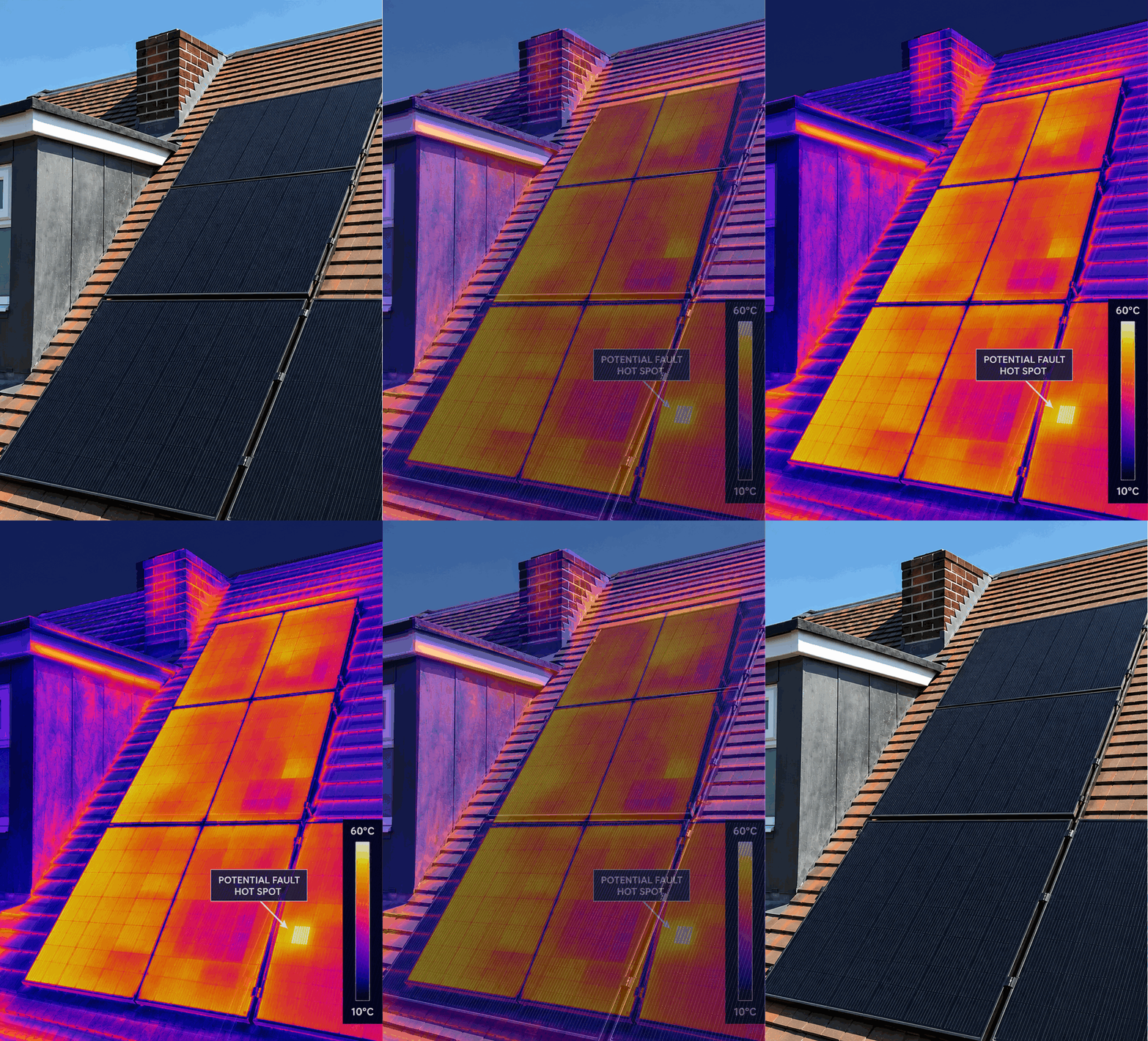
Thermal Drone Inspections →


Why Choose ProVision Drones?
Independent - We are independent from roofing contractors and don't undertake the repair work identified during our inspections.
Experienced - More than 20 years' experience within the building and construction industry.
Professional Reporting - Independent RICS surveyor reports are available where required.
High-Resolution Imagery - Detailed aerial photographs allow difficult-to-access roof areas to be examined closely.
Fully Insured - Professional drone operations with up to £10 million insurance cover.
Nationwide - Based in Essex and operating throughout London, East Anglia and across the UK.


Drone Roof Surveys Across Essex, London & the UK
Based in North Essex, ProVision Drones provides residential and commercial drone roof surveys throughout Essex, Suffolk, London, Cambridgeshire, Norfolk and nationwide.
We regularly work throughout Colchester, Chelmsford, Braintree, Ipswich, Cambridge, Norwich and London, while larger commercial projects can be undertaken anywhere in the UK.
Our services include flat roof inspections, full roof surveys, thermal solar PV inspections, annual condition surveys and aerial photography, for both residential and commercial properties.
We also provide professional defect reports, independent RICS surveyor reports and specialist thermal reports for insurance purposes, helping clients identify defects, plan maintenance and monitor property condition over time.
Additional Drone Services
Thermal Solar PV
Specialist drone thermal inspections to identify potential solar panel faults, hotspots and performance issues, with professional reporting available.
Construction Monitoring & Mapping
Regular aerial site inspections, progress photography and mapping to support construction projects, site management and development monitoring.
Aerial filming & Photography
Professional high-resolution aerial photography and 4K video for property marketing, commercial projects, developments and promotional content.
3D Mapping & Photogrammetry
Detailed aerial mapping and 3D models using photogrammetry, providing accurate visual data for site surveys, measurements and project planning.

FAQs
